
Trees
Our most current Urban Tree Canopy Assessment shows a decline of both the number of trees and their canopy cover. In the face of a changing climate and hotter temperatures, we must maintain and enhance our community tree canopy.
We are counting newly planted trees towards a goal of planting 100,000 trees by 2025 across O‘ahu, and the City is committed to increasing the urban tree canopy to 35% by 2035.
Key Projects

Maintaining and Enhancing O‘ahu’s Tree Canopy
Re-foresting our island home is a kākou effort. This crowdsourced map celebrates both private and public tree plantings islandwide. Watch this video to learn how to place your newly planted tree on the 100K Trees O‘ahu Map!
To contribute your newly planted tree to the map, fill out this survey.
We have officially passed the halfway point in our goal of planting 100,000 trees across Oʻahu by 2025! This progress supports Resilience Strategy Action 33 and the City's commitment to increase the community tree canopy. Mahalo to everyone who has recorded newly planted trees; keep recording and keep up the great work!
Trees make our communities more beautiful while providing multiple free environmental services. They are essential components of both climate change adaptation and mitigation, and shade us from increasing heat so we can have cool, livable, walkable communities.
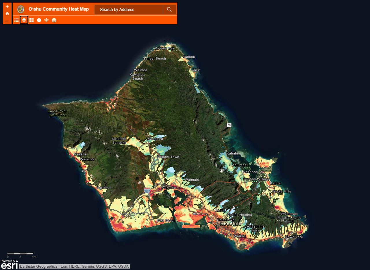
O‘ahu Community Heat Map
On August 31, 2019, staff and volunteers collected over 77,000 measurements of temperature and humidity across O‘ahu. The results help us better understand how urban heat varies across neighborhoods and how local landscapes affect temperatures. The numbers also provide insights on what future average temperatures could be without climate action and adaptation. Read the Honolulu Oʻahu Community Heat Assessment to learn more.

O’ahu Heat Vulnerability Map Series
In 2019, Hawaiʻi experienced its hottest year ever recorded. Average temperatures will continue to rise for years to come. Explore this Oʻahu Heat Vulnerability Map Series to learn more about how high heat intersects with social vulnerability in our island’s local communities.
New Heat Sensor Research Study

Related Work

Citizen Forester Program
Department of Land and Natural Resources,
Division of Forestry and Wildlife and Smart Trees Pacific
The Citizen Forester Program trains Hawaiʻi residents to become community forestry leaders. As volunteer citizen scientists, they update the urban tree inventory and contribute to an understanding of the essential role of trees in our neighborhoods.

Urban Tree Canopy Assessment
University of Vermont Spatial Analysis Laboratory and Smart Trees Pacific
This project applied USDA Forest Service’s urban tree canopy assessment method to evaluate a portion of Oʻahu’s tree canopy and conduct a change detection analysis. Learn more about this project and explore the canopy.

Department of Parks and Recreation, Division of Urban Forestry
Showcasing Oʻahu's kumulāʻau (trees) and those who mālama (care for) our forests
